TLDR;
This webinar discusses how to effectively manage facility assets within the ArcGIS Indoors environment by integrating Enterprise Asset Management (EAM) systems with GIS. It highlights the importance of data integration, the role of GIS in asset management, and strategies for managing asset data. The presentation covers data integration methods, best practices, and demonstrations of implemented solutions, emphasizing real-time data access and synchronization.
- Importance of integrating EAM systems with GIS for efficient asset management.
- Strategies for avoiding data silos and ensuring data quality.
- Practical demonstrations of asset management within ArcGIS Indoors.
Intro to Enterprise Asset Management Systems [1:25]
Enterprise Asset Management (EAM) systems track physical assets throughout their lifecycle, from procurement to decommissioning. These systems support scheduled maintenance, work order management, inventory, performance monitoring, and compliance. EAMs help organizations track assets like fire alarms, smoke detectors, and accessibility features to ensure compliance with regulations. They are supported by relational databases and designed for integration with third-party systems. Examples of EAM vendors include IBM Maximo, Infor, SAP, and Oracle asset Works.
Importance of Data Integration [3:36]
Data integration is crucial because asset data is vital across the entire organization and used by various business systems, including resource planning, financial management, and HR. Real-time access to asset data enables efficient decision-making and eliminates the need for manual data exports and spreadsheets. Integrating data reduces redundancy, ensures seamless operation across departments, and establishes a single source of record for asset information, improving efficiency and reducing costs.
Role of GIS in Asset Management [7:36]
GIS benefits asset management by providing a visual and geographic context to assets. Accessing asset data in GIS enables spatial analytics, such as determining the nearest accessible entrance or the number of fire extinguishers on each floor. GIS can be used for site selection, prioritizing maintenance, providing maps to maintenance crews, and mapping critical assets for emergency response. This leads to enhanced decision-making, improved efficiency, better resource allocation, and cost savings, all dependent on real-time data updates.
Data Management Strategies [9:29]
Key data management strategies include avoiding data silos, leveraging APIs for data exchange, and automating data synchronization. Establishing common data standards, such as a universal asset ID, is crucial for consistent communication across departments. Quality assurance, enforcing data validation rules, and a strong data governance policy are essential. Eliminating data redundancy and identifying systems of record ensures data accuracy and reliability.
Key Data Integration Methods [12:29]
Cloudpoint uses several tools for data synchronization and integration, including direct connections to APIs, FME, and the ArcGIS Data Interoperability extension. FME is a powerful tool for data integration with built-in transformers that connect to APIs, automating processes and ensuring seamless data transfer. Python scripts, OGC standards, Zapier, and Moft are also used for data sharing and triggering actions. Tableau and Power BI are used as data analytics platforms that integrate with GIS and asset data for creating dashboards.
Managing Asset Data in GIS with ArcGIS Indoors [15:39]
To integrate asset data into GIS, particularly within the ArcGIS Indoors data model, spatial attributes are managed in GIS, while non-spatial data is stored in the EAM. The GIS asset record contains the asset ID, facility, level, site, and X, Y, and Z coordinates. The asset ID links to the EAM, which contains maintenance information, performance data, and work order details. Relationship classes maintain the separation between spatial and non-spatial data, synchronizing the asset data table with the asset database after edits.
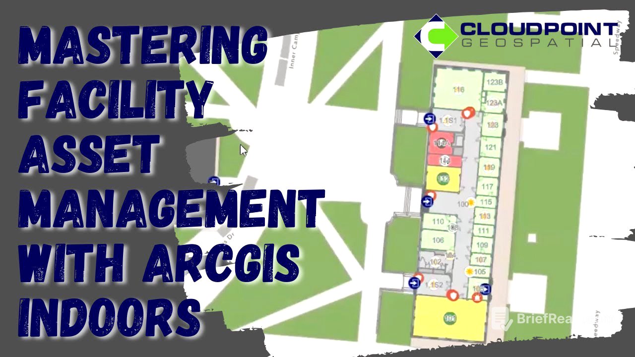
Demos of Implemented Solutions [18:04]
Demonstrations include a pilot study for the University of Texas at Austin, showcasing a building's CAD data loaded into an ArcGIS Indoors data model. The floor picker filters data layers, and asset data is overlaid on the map, with categories and subtypes from the asset management system. The map is published as a web map to ArcGIS Enterprise and brought into the ArcGIS Indoors viewer, allowing users to navigate to assets, view them in 3D, and get turn-by-turn directions. Additional apps include a building asset editor for creating and editing features and a dashboard app for browsing and summarizing asset data. Panoramic photos taken during building surveys are combined with asset data for better visualization.


![★[걸리버 여행기] 설민석 강독 풀버전★ 동화? NO! 발간 직후 금서로 지정된 문제적 풍자문학 | 요즘책방 : 책 읽어드립니다 The Page-Turners EP.30](https://wm-img.halpindev.com/p-briefread_c-10_b-10/urlb/aHR0cDovL2ltZy55b3V0dWJlLmNvbS92aS82bmxvUThyUGdrYy9ocWRlZmF1bHQuanBn.jpg)