TLDR;
This video discusses land and marine seismic acquisition techniques, highlighting the impact of survey design and technology on data quality and interpretation. It covers various aspects such as energy sources, survey geometry, fold coverage, acquisition footprints, and the influence of ocean currents. The video emphasises the importance of understanding acquisition parameters to avoid misinterpreting data and improve the accuracy of subsurface imaging.
- Land acquisition uses vibrators and dynamite as energy sources, with vibrators providing improved signal-to-noise ratio.
- Survey geometry and fold coverage significantly impact data quality and can introduce acquisition artifacts.
- Marine acquisition involves towing air gun arrays and hydrophone streamers, with challenges like ocean currents affecting streamer positioning.
- Ocean bottom cables and nodes offer better data quality but are more complex and expensive to deploy.
- Geometry matters, acquisition footprints can mimic geologic structures, and understanding acquisition parameters is crucial for accurate interpretation.
Land Acquisition Techniques [0:01]
The video begins by comparing land acquisition methods, specifically vibrators and dynamite as energy sources. Vibrators, a more modern approach, generally provide an improved signal-to-noise ratio compared to dynamite. A comparison of records from Southeast Montana shows that vibrator records exhibit more coherent reflections, which are harder to discern in dynamite-acquired data. The presenter notes that while modern 3D data is easier to interpret, these older records present more uncertainty.
Survey Design and Fold Coverage [1:23]
Every seismic survey has distinct quality zones that impact interpretation. The area of interest, or "sweet spot", is surrounded by a fringe area. Seismic surveys must extend beyond the reservoir to allow for larger offset angles and maintain fold for noise reduction. An image of fold coverage from a land survey illustrates how fold builds up from the edges to the centre. Areas with lower fold may have reduced statistical noise reduction, making subtle features harder to interpret. Stripe patterns in fold acquisition can cause acquisition artifacts in the seismic data, often referred to as the acquisition footprint.
Survey Geometry in Land Acquisition [3:15]
Survey geometry in land acquisition varies based on terrain, obstacles, cost, and equipment constraints. Cross-spread shooting, first used in the 1970s, and perimeter shooting are two variations. Perimeter shooting involves placing sources around a regular or irregular area, with source and receiver lines often coincident. This method allows for flexibility in undershooting obstacles, providing more CMP image coverage with minimal surface access and source effort.
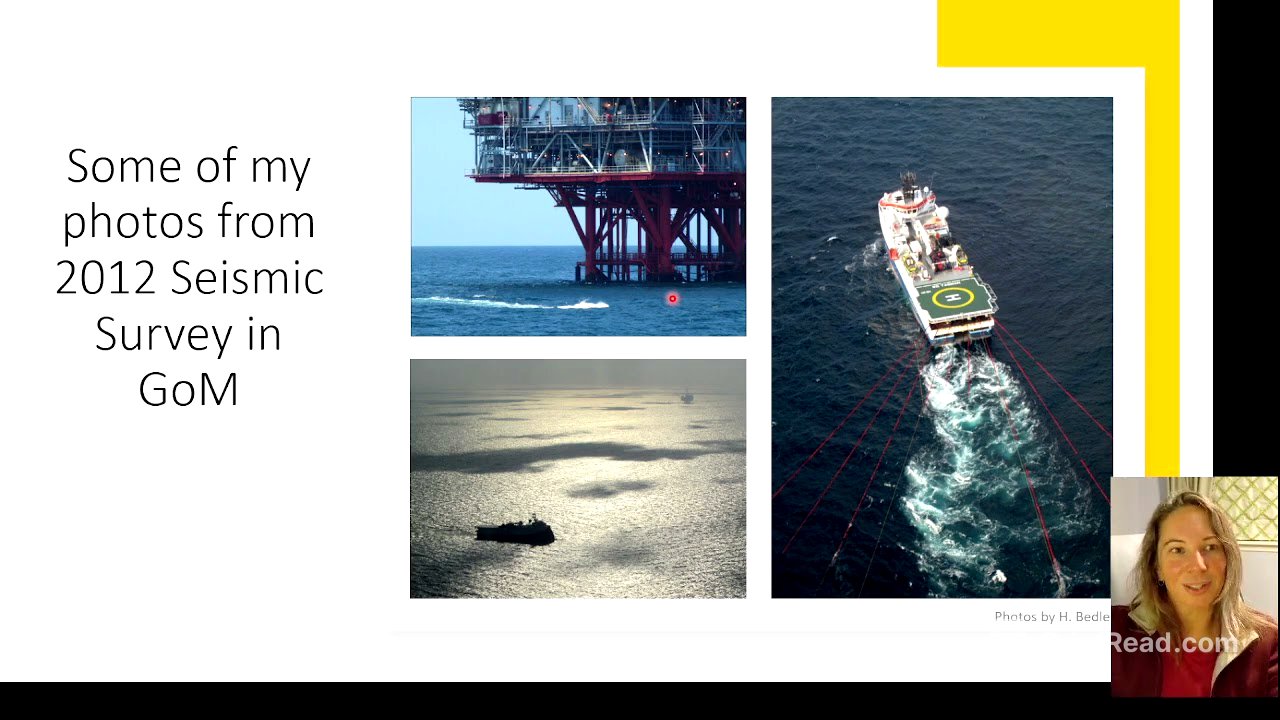
Marine Acquisition Overview [4:46]
The video transitions to marine acquisition, using an image to illustrate key elements such as a source vessel towing air gun arrays and long hydrophone streamers. Vessels typically follow carefully planned sail lines in a racetrack pattern to ensure proper coverage. The presenter shares photos from a seismic survey in the Gulf of Mexico, noting the use of streamers and air guns. A 4D survey required working around existing platforms, necessitating two phases of seismic shooting with smaller vessels.
Marine Acquisition Equipment and Challenges [6:40]
Equipment from a marine survey includes air guns and streamer decks. The presenter shares a photo of live data from the data QC centre, highlighting its noisy appearance before processing. Ocean currents pose a major challenge, causing streamer feathering, where streamers drift from their intended path. This affects subsurface coverage and must be accounted for during processing and interpretation.
Ocean Bottom Technologies [7:52]
Ocean bottom cables (OBC) are a great alternative if affordable, laid directly on the seafloor with hydrophones and geophones. They provide better low-frequency response and allow recording of both pressure and shear waves. Deployment can be complex and expensive. Ocean bottom nodes (OBN) are individual nodes placed in areas where cables are impractical, offering very good data quality but are even more expensive to deploy and retrieve.
Comparison of Marine Acquisition Methods [8:58]
A comparison between traditional streamer acquisition and ocean bottom nodes shows how different methods affect imaging capability. Ocean bottom methods provide better illumination of complex structures. Subsalt images at the "Meine" level demonstrate higher resolution with OBS compared to towed streamers. Wide azimuth node imaging with OBS offers advantages over narrow azimuth towed streamer images.
Impact of Geometry and Acquisition Footprints [10:21]
Geometry significantly impacts seismic data; shooting parallel or perpendicular to faults can change their appearance. An example shows how different geometries illuminate features differently. Acquisition footprints, unavoidable artifacts resulting from acquisition geometry, can be mistaken for geologic features. The presenter emphasises the importance of identifying these footprints to avoid misinterpretation.
Key Concepts in Acquisition [11:54]
The video concludes by reiterating key concepts: survey geometry affects seismic data, different azimuth coverages exist, acquisition artifacts can mimic geologic structures, and better azimuth coverage improves imaging of complex structures. Checking acquisition and processing reports can help understand unusual features encountered during interpretation.